In my last post I managed to travel back in time with my house (potentially) and the land (definitely) to 1671, when a John Cook lived here, and the land passed from Henry Long Esq of Rood Ashton to Edward Pierce ,the elder, (a draper from Devizes ).
But while I was looking at online documents on Poulshot, trying to find out more about this transaction and the history of the land, I came across this comment in the archeological report completed before a solar park was installed. “There were two manors at Poulshot, so it is possible that one was located at the church while the other was located to the north in the area of the Green, where medieval development seems to have taken place in the 12th or 13th century (KDC 2004, 2). Within the Green today there are possible settlement earthworks (RCHME 1996).” The comment made me think – if the second manor, Poulshot Manor, was near The Green, and our house was potentially the oldest house on the edge of The Green – could our land have been the site of the manor?
Of course that became my next mission. But how could I know? It would take a lot of historical researching (spy) skills 🙂
I found this Thesis Village Greens of England published online. This explains the different structures of Village Greens, and how greens came about.
Common land for the use of commoners was in place in the medieval period, and at this time the use was administered by the local manor (although all land was owned by the King and only on lease for tithes).
“MEDIEVAL INCLOSURE In the Middle Ages, before the very first statute was enacted in 1236,25 the Lord of the Manor could inclose commons or greens by two methods at common law:- by agreement with all the commoners or by exercising his right of approvement 26 According to Halsbury, 27 reaching agreement with all the commoners was difficult in practice and is now probably obsolete. 28 The Lord’s right of inclosure was extended and made statutory by the Statute of Merton 1236 and the Statute of Westminster II 1285,29 a right which is now also probably obsolete. 30 The Statute of Merton allowed the Lord to inclose the common providing he allowed sufficient pasture for the commoners and allowed them free access to and from the common (see appendix 5). This was confirmed and extended by the Statute of Westminster II, 1285, and is still a current statute.”
And the greens, the waste (un-farmed) land continued to pass down with the Manor lands.
“Ownership of greens and commons historically went with the manor and were owned by the Lord as his waste or uncultivated and unoccupied land. This was confirmed by the statute of Merton 1236. Prior to the development of the manorial system, common land may have been common property and came into private ownership as early as the 9th century under the imposition of the manorial system. 51 In early times the waste was the land within the manor that had not been inclosed for farming and may have been wooded or open country. In the 12th and 13th centuries, as the population grew arable farming was increasing to supply the extra food and these pieces of waste became more important for pasture for animals to plough the fields. Many manors were held by absentee landlords who could be people such as great Lords or bishops, an Oxbridge college or ancient public school or even the King. Manors which had an absentee Lord were frequently leased out.”
Poulshot’s Green, is what would be called a Residual Green. These are recognised as being common in areas with a number of small manors, where wasteland gradually becomes a populated area.
 “RESIDUAL GREENS Greens which are not the result of formalised planning but are formed from the presence of former elements in the landscape ( such as commons or the boundaries between territories ) are termed residual greens. It has been recognised that this type of green …is associated with a distinctive form of dispersed settlement pattem. In such cases, it should be noted that the greens or commons on which the settlement has accreted have long been there, it is not until the settlement arrives that they actually become village greens (a term which includes settled pieces of green or common without the size and status of a nucleated village ) . Residual greens may be formed from pieces of common or wasteland being colonised by settlement Such greens are typically different from planned greens in a number of ways, most obviously in that they frequently have a ‘green name’ and have a strong association with the woodland zones of England. Residual greens tend to be later formations than planned integral or peripheral greens,” Poulshot Manor was in the middle of a Royal Forest. “and are often in more marginal environments. A useful study of such greens has been undertaken by Warner (1987) who noticed similarities between greens on the Suffolk claylands and those in the north London suburbs, and the claylands of south east Birmingham, Norfolk, south Buckinghamhire and East Hertfordshire. He suggested that the presence of divided lordship was an important factor in their formation. Numerous freemen under divided lordship allowed a recolonisation of the claylands before 1086 with such lordship and numerous small manors a reflection of the dispersed greenside settlement pattern which largely remained ( with a few desertions – and probably a few additions ) until the inclosures.”
All of the above seem to confirm that Poulshot Manor House would indeed have been by The G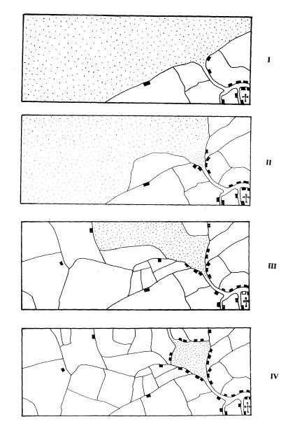 reen.
reen.
The greyed areas in these images show you how these village greens were formed.
In figure one, while the church and village are away from the common (waste) land, the manor house stands at the entrance to it.
In figure two, you can see more houses have moved near the common land and that there has been some encroachment into the waste land.
By stage three, you can see that the population has begun to farm much more of the waste land, and so the green has become enclosed by farmed land.
The last image shows you how eventually the population of the village has moved away from the church and now the community surrounding the green has made the green the heart of the village.
 The above depiction of a village green developing over time could be an image of the shift in our village. With the church left with a few buildings surrounding it at the bottom of the hill.
Another little bit of information to add to the mix was a record made in a book written by people who lived in the village in the 1960s Hooke and Stevenson. Their last words on Poulshot Manor, “…it was sold to Thomas Long, clothier, and great uncle of Gifford Long who died holding the manor in 1635.” Although annoyingly they don’t say where they found this information.
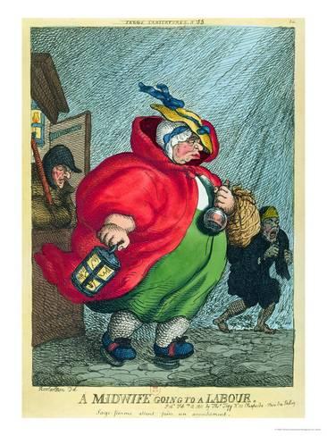
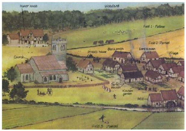
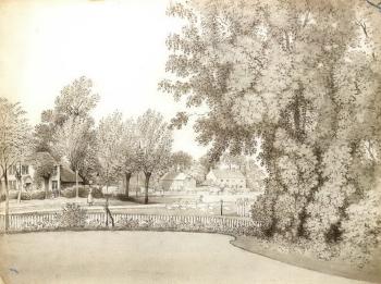
I imagine Poulshot once looked similar to this drawing…
If you go back to my last post, you’ll see that Henry Long Esq of Rood Ashton who sold our land in 1671,was the Grandson of Gifford Long, and in the direct line of inheritance through his father. Which means that it is highly likely that the share of the Poulshot Land in Henry’s inheritance included Poulshot Manor, while his distant cousins still owned the land belonging to nearby Burdon’s Manor.
It is not so much a village myth, but a village vacuum of information because no one else has been able to see where the manor disappeared to after Gifford Long. It was then assumed, in the absence of contrary evidence, that the manor must have been somewhere on the lands that remained in the hands of Henry’s distant cousins. Especially as when Henry died in 1672 he left no heirs. But other people had not come across the Indenture recording the exchange of Henry’s Poulshot Property in 1671.
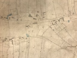
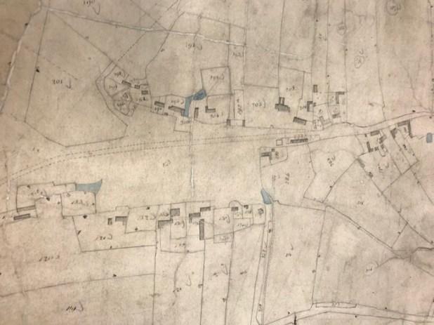
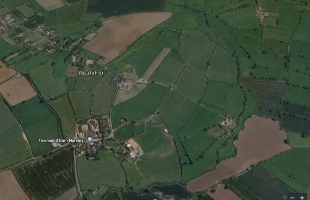
 So, I am at this point certain that the manor was somewhere on the land that passed on down with our house for centuries. If you go all the way back to my first post. Showing the map of that land you’ll see only two properties. Ours with an orchard, untitled, and the second below ours, which to this day is called Manor Farm.
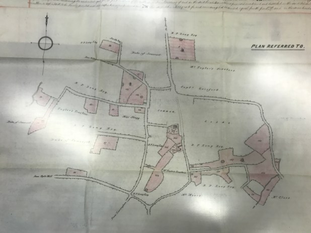
There’s something then very notable about the site of our land too – while the other houses enclose the green, ours is on the end of it (Plot 284 on these maps). On a site also at the end of both the original access roads. So going back to figure one in the over-time drawings of the development of common land above – where the manor initially stands in isolation at the entrance to the common land – this would relate. So it is very possible that the property at this site controlled the access to, and managed, the original waste/common land that became Poulshot Green after the Civil War.
You might be thinking, she’s bonkers, that’s a long jump. But all archeology includes some initial element of belief and theorising. But next I started looking to see if there was any evidence to support it.
Knowing that several archeological records have said there was probably a moated manor here, I set off to use the fieldwalking skills I’d learn in my childhood for any clues in the landscape.
 As much as I said in the first post, that I’d always thought the very wide “green lanes” pathways around the village were unusual (and they turned out to be redundant roads), there is also a lumpy bumpy field (plot 285 above – plot 284). Plot 285 has lots of oddly shaped unnatural looking ridges, and ever since we moved here I’ve felt there was something archeological going on in that field. While plots 215 and 214 have ridge and furrow markings which mean people were ploughing it with hand driven ploughs for many years.
When I walked into the lumpy bumpy field the first thing I noticed was that there’s a perfectly rectangular long pond on the left (not marked on the above map but in the farthest right top corner of plot 285), and in front of me was a ridge about a meter high. That ridge runs all the way along the front of the lumpy bumpy field behind a row of cottages and then along the outer edge of the land our property is on. This slope up is on the boundary line of plots 285, 284 and 283.
On the map above, where the land is coloured in pink, you can see that field number 285 later filled in the space from the original boundary to the road.
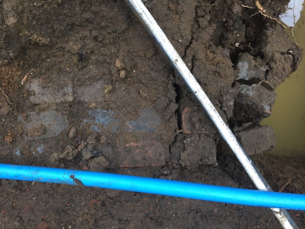
But the pictures below show you the line of the pond following the original boundary, which shows up in the field. Also at the farthest end of the pond, there’s a brick wall that suggests the pond used to turn the corner there.


As I walk on into the field, there are loads of unusual ridges, and a circle of mud that never seems to grow grass (a former well???). Then on the right, there’s a clear furrow that runs along and then turns, in the field. I can see at some point the furrow was a field boundary because on the far side are plough marks.


But its the way the furrow turns in the field (as you can see on plot 285 above) and the placement of that turn that’s interesting, because the position is aligned with another pond, that is shown on the map above. The pond turns at the lowest lefthand point of plot 284, and is also dammed on one side.


 The area of grass in front of our house also sometimes floods in the winter, forming a pond that aligns with the long rectangular pond. The moat potentially then ran around the boundaries of plots 283,4 and 5. Which means the moat was not geometrical – but not all moats were geometrical, as can see at the site at South Kyme.
So now I’ll try not to bore you with too much of my additional delving, but the things I know about the manor from various sources are;
- That it was initially built on a plot of cleared land in the middle of a large forest.
- That in the Doomsday book, Poulshot is listed as being 3 hides, which means it was a small settlement.
- That the person the Manor had been allocated to via the feudalism system, never used the property as a primary residence, from 1066 until 1600s, and even through most of the 1900s the property was let to a tenant.
- That all sources agree the manor was positioned on the highland where the green was formed.
I’ve also found this piece of history recording the ownership of the Manor through the ages…
“A grant in 1216 by the king to Hugh de Bernevall of land in Poulshot may refer to this manor. (fn. 28) In 1272 Ralph de Paulesholte settled the manor as a messuage and a carucate of land in Poulshot and elsewhere upon himself and his children John, William, and Alice. (fn. 29) John de Paulesholte had succeeded his father by 1289 (fn. 30) and in 1322 he forfeited all his possessions. (fn. 31) As part of his manor, John held 32 acres in the forest of Melksham. (fn. 32) His lands were restored to him before his death in 1330 when he was holding the manor of Poulshot and land in ‘Chitumersche'(Chittoe Marsh). (fn. 33) John’s heir was his kinsman, John Enok of Potterne, son of William Enok. It seems probable that John Enok is the same as John de Paulesholte, upon whom with his wife Margaret the manor was settled in fee in 1335. (fn. 34)
In 1383 the manor was conveyed by Henry Eyre to Sir John Lovel. (fn. 35) Sir John died in 1408 and was succeeded by his son John. (fn. 36) In 1412 this John, by then Lord Lovel, conveyed the manor to William Stourton. (fn. 37) From this date the manor passed in the Stourton family until 1545 when it was sold to Thomas Long, clothier, of Trowbridge.”
You can see in this record who owned the manor 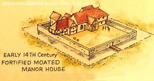 in 1322.
But what did the manor look like then?
In the medieval period people did not have the morals we know today, and local violent (deadly) quarrels broke out all the time, even when the country was not fighting a civil war. Disputes, raids and local battles occurred all the time. People killed, stole property and livestock. Edward II reigned during 1322 and there were many disputes because Edward II was considered to be a weak and ineffectual King, who was overthrown five years later, and then murdered at Berkley Castle.
The fortified manors were generally surrounded by a moat and wall. I imagine the manor on our land was like the property above. Those that survive today in the images below are much grander, but that’s because they became a primary residence of an influential family, which ours never did.


But the other thing I know about the moat around Poulshot manor is that there is one listed cottage, among a row of cottages built on top of where the moat would have run, that’s dated 1656. That means if I am right about the position of the moat it had already been filled in by the late 1600s when the occupants of the village moved up to the land around the green.
But then I found this record in The Book of Devizes by Edward Bradby, “In May 1644 there was a raid by Parliamentary forces when several Royalist supporters were arrested, including a Senior Burgess, Michael Tidcome; and the Constables of Potterne and Cannings were ordered to demolish the ‘works and fortifications … now standing about Devizes“ It’s likely, then, that it was on this order that the manor was destroyed and the moat filled in. So if this is right the fortified manor was in its heyday from 1322 until 1644, and then perhaps no longer there.
More evidence that the manor was in this area and in the land that came from Henry Long Esq, is in the field names of the estate. Going back to my first post, in the 17-1900s records I saw the field names Pug Pit and Butts change to Pig Pit and Butts.


The Pig Pit was separate to the general common land because pigs break up and destroy pasture, turning the land to mud, which would have meant there was no pasture for other stock. So pigs were banished from the green land and owners of pigs fined if they let them feed on the main common. While in the Middle Ages and Tudor times, by law, every man had to practice archery on Sunday afternoon, and of course, they would have practiced at The Butts. 🙂
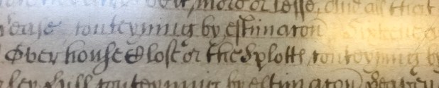 I have also looked at the name the Splotts, that I saw on the earliest documents, that I believe was the name of the land our house was built on. As it’s such an unusual word I
  feel like it must have an old English meaning. The only things that I can find are similarly named places at Glastonbury, in Wales and in the North of England, but interestingly all these places are on the edge of hills. Which our land is, and the only similarly connected word I can find is “sprot” meaning twig or small branch, which, as the manor would have been at the bottom of the G (of the word Green) on this map it is on the brink of a branch of higher ground… Which would, of course, have given the occupants a good view of who was coming along the roads so it is a good defensive position for occupation.


So, yet again, research has lead me to discover that there is so much left to be discovered. 🙂 But now I believe we are on the land of Poulshot Manor, I can follow records back for decades as tithes were paid to the Monarchs, and then on down from that.
My research from now will be to trace back through the wills and tithe records of the lords who owned Poulshot Manor, to see if I can find descriptions of the land, of what and who was here, and how they lived.
 Fee of fines Entries ABSTRACTS OF FEET OF FINES RELATING TO WILTSHIRE
1431
Morrow of Purification. Ralph Thorp, esquire, and Philippa his wife, pl.; Robert Dyngley, clerk, def. Manors of Boscombe (Borscombe), Burdens Ball (Burdonesballe) and Poulshot (Poulesholt), and 7 messuages, 11 virgates, 8 a. meadow and rents of 3s. I/ad. and 1/2 lb. pepper in Allington (Alyngton), Newton Tony (Neuton Tony) and Middle Winterslow (Wyntreslewe Middelton) and the advowson of Boscombe. Def. granted and rendered to pl. To hold to pl. and the heirs of their bodies. Remainder to his right heirs.
1412
Oct. of Trin. William Hankeford, knight, John Chitterne, clerk, John Bathe, clerk, and William Stourton, pl.;John Lord Lovell, knight, def. Manor of Poulshot (Poulesholt), and 8 messuages, 8 virgates and 8 a. meadow in Poulshot, Potterne (Poterne), Marston (Mershton) and Worton.
1388
Oct. ofHil. (Made quin. ofEas. 7 Ric. ll [1384]). Thomas Worfton and Cecily his wife, by Thomas as her guardian, pl.; John Burdon, def. Half the manor of Poulshot (Paulesholte) which Agnes Cuttyng holds for the term of her life with remainder to Thomas Cuttyng for the term of his life of the inheritance of def. Right ofdef. Grant of reversion to pl. and the heirs oftheir bodies rendering a rose yearly to def. at S.J.B. Reversion to def. (Warranty) Agnes was present and consenting. Thomas and Cecily have done fealty.
1353
Oct. of Mic. Nicholas Burdon and Denise his wife, pl.; Julius, vicar of the church of Toynton, def. Manor of Paulesholte. Right of def. by gift of Nicholas; grant back and render to pl. To hold to pl. during their life. Remainder to Peter de Testewode and Agnes his wife during their life and the right heirs of Nicholas.
1347
Quin. of Mic. John de Paulesholte and John de Kyveleye, pl.; Robert Mareys and Helen his wife, def. Two messuages, l mill, 1% virgate of land, and 3 acres of meadow in Great Chiverel and Mershton by Poterne. Right of John de Paulesholte, pl. having 2 parts of the said tenements by gift of def.; grant back and render to def. To hold to def. from pl. during def.’s life, rendering yearly l rose at S.J.B. Also grant to def. of the reversion of the third part, which Joan who was wife of Thomas Ennok holds in dower in the said townships. To hold as above. Remainder to Richard, son of def., to hold as above during his life.
1335
York. Quin. of Trin. (Made three weeks from Eas.) John de Poulesholte and Margaret his wife, pl.; William de Chiltenham, def. Manor of Poulesholte. Right of def. by gift of John; grant back and render to pl. To hold to pl. and the heirs of their bodies. Remainder to the right heirs of John.
1308
Three weeks from Eas. Hugh Wak’ and Joan his wife, pl., by Roger de Stok’ in his place by the king’s writ. Adam de Paulesholte, def. Manor of Wynterburnestok’.
1303
Oct. of S.J.B. Walter de Pavely, Joan his wife and Walter, son of Walter de Pavely, pl., by John de Paulesholte in their place. John de Tany, def., by Thomas le Paumer in his place. Manor of Hulprinton’. (F.) Remise and quitclaim to d-éfi, the heirs of the body of the same Walter son of ‘Walter and the right heirs of Walter de Paveley.
I297
Oct. of Martinmas. William de Rolveston’ and Margaret his wife, pl. Parnel de Bovill’, def., by Adam de Paulesholte in her place. I messuage and II virgates of land in Orcheston’ Bovill’ and the advowson of the church of the same town. (C.) Def. to hold during her life of pl., rendering yearly I rose at S.J.B.
As usual there are P.Ss 😉
There is a record on the Wiltshire Archeology site of another moated area down by the church, and evidence of a fishpond down there. I looked at this on earth.google.com


It’s a much smaller area that’s enclosed. But more notably, which might mean something to someone who is trained in archeology is that – the site is at the bottom of a circular area of land, that our plot is at the top of…
P.P.S While I don’t think our house was the original manor because it’s too small and it’s in one corner of the moat, I do wonder if our house has some of the early timbers.


 P.P.P.S for those of you who have followed me for a long time, there’s an old tree outside the manor boundary… My brain is thinking was the tree young when the manor stood here. 😉
Perfect Period Drama
from Jane Lark
The rule of the red thread of destiny says that everything that is unresolved will be resolved
~
The Thread of Destiny
~
The Lure of a Poet
Discover all of Jane Lark’s books


 The image was drawn from the parlour of the vicarage on the far side of the road from where we are. The drawing below was sold by


 own half of, is at the bottom of the village green. Plot number 283, homestead and garden. At the time the occupants of our house were also leasing plot 284, the orchard.